


In what appeared to be a bizarre attempt to justify a days-old tweet, President Donald Trump on Wednesday publicly displayed a doctored, nearly week-old image of Hurricane Dorian’s projected path, in an apparent effort to save face by claiming he was right when he wrongly said Alabama was at risk.
In fact, Alabama was never at risk, according to the National Weather Service. After causing catastrophic damage in the Bahamas, Dorian is now off the Florida coast and headed up the Atlantic seaboard. About 3 million people from Florida to North Carolina have been warned to evacuate.
On Sunday morning, as Dorian was still approaching the Bahamas and its potential U.S. landfall was unclear, Trump tweeted that, in addition to Florida, “South Carolina, North Carolina, Georgia, and Alabama, will most likely be hit (much) harder than anticipated.”
However, Alabama was not in the storm’s “cone of uncertainty,” and about 20 minutes after Trump’s tweet the National Weather Service tweeted: “Alabama will NOT see any impacts from #Dorian.”
A NOAA spokesman told the Associated Press on Sunday: “The current forecast path of Dorian does not include Alabama.”
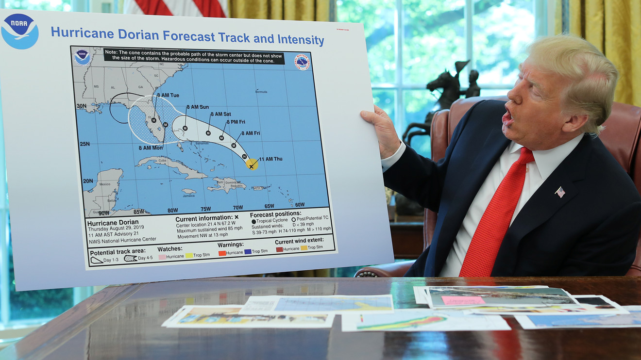
Then Wednesday, in an apparent effort to show he was right all along, the White House released video of Trump showing reporters a NWS map of Dorian’s projected path, dated Aug. 29, which he said was the “original chart” showing the hurricane headed toward Florida and potentially moving toward the Gulf Coast.
But in the map he used, Dorian’s official projected path stops short of Alabama — though what appears to be a drawn-on second bubble does extend to Alabama. The second bubble, crudely drawn in black ink, was not part of the original NWS projection.
When reporters asked Trump if the second bubble had been drawn on, he replied: “I don’t know, I don’t know.”
Trump insisted that unspecified “other, better maps” showed Alabama could have been impacted. The National Oceanic and Atmospheric Administration, which runs the National Weather Service, did not comment Wednesday, and has not publicly released any maps showing that.
Following a number of critical media reports Wednesday afternoon, Trump tweeted an image of Dorian predictions that did include Alabama, and said he will “accept the Fake News apologies.”
However, that map was dated Aug. 28, which made its projections long outdated by the time Trump tweeted Sunday. Furthermore, the map, which was taken from the South Florida Water Management District website, clearly states that National Hurricane Center information supersedes it. “If anything on this graphic causes confusion, ignore the entire product,” it reads.
If the map Wednesday was altered, it could actually be illegal. According to 18 U.S. Code 2074: “Whoever knowingly issues or publishes any counterfeit weather forecast or warning of weather conditions falsely representing such forecast or warning to have been issued or published by the Weather Bureau, United States Signal Service, or other branch of the Government service, shall be fined under this title or imprisoned not more than ninety days, or both.”
Wrongly including Alabama in his warning had practical issues too, including the potential for unnecessarily panicking residents and misallocating disaster resources, and lessening the public’s trust in NWS forecasts.
Perhaps coincidentally, shares of Newell Brands Inc. NWL, +4.30% , the company that owns Sharpie markers, rose more than 4% on Wednesday.